The Mining History of South Mountain - Revisited
Destination Arizona
B. Thomas Cooper
Editor
South Mountain, the vast mountain range south of central Phoenix boasts miles of trails, and boundless recreational opportunity, but its rugged interior wasn’t always ideal for a family outing. In fact, South Mountain has changed little since its hardscrabble days as the second largest gold producer in Maricopa County.

Towers at South Mountain
Nine miles from the heart of down town Phoenix, South Mountain Park serves as a backdrop for the growing, ever diverse, Valley of the Sun. At nearly seventeen thousand acres, it remains the largest municipal park in the US, and for many visitors, its rugged allure is difficult to resist.
Some come to South Mountain to test their hiking skills among the nearly 60 miles of scenic trails. Others visit to experience the magnificent view of the valley from atop Dobbins Point, 2330 feet above sea level. There is always a virtual plethora of wildlife and desert fauna to delight the eye, and limitless recreational possibilities.
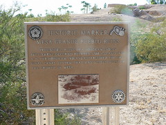
Spectacular petroglyphs, located throughout the park, tell of long lost cultures that once inhabited the region, including the Hohokam, dating back to 300 AD. The Hohokam built over 130 miles of canals throughout the valley, diverting water from the nearby Salt River to irrigate crops.
In 1867, Jack Swilling, with the help of others, established Salt River Project, repairing the ancient Hohokam canals and digging new ones, returning water to the dry valley floor. Soon, the valley sprang back to life. Darrell Duppa, an associate of Swilling suggested naming the fledgling city after the mythical Phoenix Bird, a splendid winged creature that arose from its own ashes. The name stuck, and the city of Phoenix was officially incorporated on Feb. 15, 1881.

South Mountain Cultural Center
By the late 1800’s however, it wasn’t just water attracting new residents to the valley. Mining was becoming big business in the Arizona territory. With statehood (and air conditioning) still years away, the main attraction within the rocky range south of Phoenix was gold! Claims for gold, silver, copper and other precious metals sprang up throughout the region. South Mountain was no exception.
By February of 1900, while William McKinley was beginning his ill-fated second term as US President, George and Nora McClarty were filing the earliest known claim within South Mountain, the Richmond, along the northern face of the range. Several more claims soon followed in the San Juan Valley southwest of Central Avenue, including the Maximillian and Delta claims. By 1909, these claims, collectively known as the Max Delta Mine, had produced over $30,000 in gold and thousands more in other precious metals.

Petroglyphs
Although the mines were never consistent, nor particularly profitable, they were numerous and remained productive for many years. By 1913, shafts had been dug to depths exceeding 500 feet, and ore was shipped by pack train, and then by wagon to an arrastre near the Gila River.
Conditions for the miners were miserable. There was no running water at the mines, and ice had to be hauled in from Phoenix. An unskilled laborer could expect to earn two dollars for a days’ effort. Experienced miners earned about double. A boarding camp was erected on sight, consisting of a few small structures and no real amenities of which to speak. Life was hard.
The mines’ shareholders seldom fared much better. The Max Delta changed hands often, with each new owner facing similar obstacles. In 1914, as the First World War erupted, many miners found fighting in the trenches of Europe preferable to digging for gold. For a time, the mines went silent.

South Mountain Park
By the early 1920’s, residents of the valley were beginning to appreciate the recreational value of the rugged range south of Phoenix. In 1921, a group of prominent citizens led by Carl Hayden began a campaign to promote the mountain’s natural attributes. James C. Dobbins, Chairman of the Parks Committee for the city of Phoenix, convinced city commissioners of the need for preserving and protecting the land, and in June of 1924, the 68th Congress passed an act transferring ownership of the range from the federal government to the City of Phoenix for $1.25 per acre.
Mining did not cease in the park, however. Although the act of 1924 specifically stated the park was for recreational purposes, the federal government still held the mineral rights, which allowed for prospecting and removal of minerals from the park.
During the 1930s, with depression gripping much of the nation, mining and prospecting returned to South Mountain with renewed interest. Indeed, the year 1935 proved to be the most productive for the mines. That year, the Max Delta was the fourth largest producer of gold in the US, and the second largest producer of gold in Maricopa County, yielding 1,423 ounces. The Vulture Mine, west of Wickenburg, produced the greatest quantity in the county, yielding 1,802 ounces of gold.

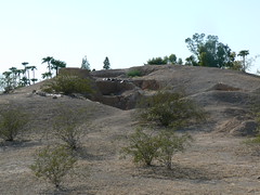
Max Delta Mine
Mining continued at South Mountain, although sporadically, for many more years. Eventually, through a procession of lawsuits and legal challenges, the mines would close. Finally, in 1993, the City of Phoenix received the deeds to the remaining patented claims on the property, and set about rehabilitating the land.

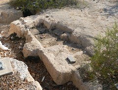
Max Delta Mine
Most of the old claims no longer present a threat to park visitors. The adits and entrances have long been bulldozed or dynamited, leaving little or no trace of the old mines. Ironically, much remains of the Max Delta. Its bulkhead and massive tailings are still quite visible from nearly any view along the San Juan Valley. The old road leading to the mine is no longer accessible, and visitors are discouraged from curiosity. Still, the remnants of the Max Delta Mine remain a reminder of a near forgotten era, when an outing to South Mountain was no family picnic.
Destination Arizona
Destination Arizona
Labels: Arizona, Arizona History, Arizona mining history, B. Thomas Cooper, destination arizona, destinationarizona, Maricopa County, max delta mine, Phoenix, south mountain
posted by B. Thomas Cooper @ 6:38 PM
0 comments
![]()
![]()

![[Valid Atom 1.0]](http://feedvalidator.org/images/valid-atom.png "Validate my Atom 1.0 feed")
 Subscribe to