Sierra Club

Destination Arizona

Arizona Travel, Recreation, Adventure, History and More. Join us along the scenic backroads, rivers and lakes of this Amazing state.

Monday, November 16, 2009

Tempe Town Lake crown jewel of Rio Salado project

Destination Arizona
B. Thomas Cooper
Editor

Live in an arid climate long enough, and one soon begins to dream of water. In Tempe, Arizona, that dream has come true, in the form of a 99 million gallon, man made lake.
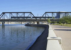
Tempe Town Lake
Tempe Town Lake

In 1911, workers completed construction of the massive Roosevelt Dam east of the fledgling city of Phoenix, Arizona. Save for the occasional flood, water would soon cease to flow through the Salt River toward the growing community downstream. The river water was redirected through an intricate canal system to accommodate farmland in the valley. What had formerly been a rich riparian habitat along the river, quickly became a barren wasteland.

Faced with starvation, wildlife indigenous to the river basin was forced to abandon the dieing habitat. By the mid fifties, the riverbed had succumbed to neglect. The dry river became home to a bevy of industry, land fills and quarries. The once glorious Salt River had reached rock bottom.

Then in 1966, a wonderful thing happened. Dean Elmore of the College of Architecture at Arizona State University came up with a wonderful, wonderful idea. Elmore and his students envisioned building a series of locks and channels along the dry riverbed. They proposed refilling the channels with water, building sections of park and greenbelt along the rivers neglected banks and rehabilitating the surrounding ecosystem. It was a grand and beautiful plan.

In 1987, after years of research and development, the Rio Salado project was finally put before valley voters. The surrounding valley communities resoundingly defeated the bill, but in Tempe, residents remained supportive. Tempe Mayor Harry Mitchell agreed, announcing the town of Tempe was prepared to go it alone. It was the beginning of what would slowly develop into Tempe Town Lake.

Eight rubber bladder dams, each 16 feet tall and 240 feet in length, were installed along the river, creating a 2-mile long lake with over 220-surface acres of water. Finally, on
June 2, 1999, Water from the Central Arizona canal began flowing into the Tempe Town Lake. 43 days later, the lake was officially declared full.

Ten years later, Tempe Town Lake has become the top attraction in the valley, with nearly three million people visiting the lake annually. It is the crowning achievement of a project over thirty years in the making.

Each year, millions of people enjoy the lake. Some boat, while others choose to walk or jog along the miles of adjoining trails. Valley parents bring their family for an afternoon picnic. Some simply come to the lake to gaze at this beautiful oasis in the middle of the bustling city.

The Rio Salado project may never be entirely completed, and perhaps that’s a good thing. Valley residents can expect the lake and the surrounding rehabilitated ecosystem to continually grow and improve with age. Downstream, mighty cottonwood trees once again adorn the riverbed and the indigenous wildlife, absent for nearly a hundred years, is slowly returning.

On Dec. 12, 2009, the town of Tempe will celebrate the tenth birthday of this extraordinary environmental achievement. The free birthday bash begins at 3 p.m., and will feature fireworks and a Festival of Lights Boat Parade, sponsored by Arizona Public Service.


Destination Arizona
Destination Arizona

Labels: , , , , , , , , , ,


Sunday, November 15, 2009

Yavapai Nation to celebrate 28th annual Orme Dam Victory Days

Destination Arizona
B. Thomas Cooper
Editor


On November 20th, 2009, the Fort McDowell Yavapai Nation northeast of Phoenix, Arizona will be hosting a big Pow Wow, celebrating the 28th Annual Orme Dam Victory Days. This, however, is not your ordinary victory celebration. This party celebrates a “dam that never was”.

Orme Dam Victory Days
. Perhaps you’ve heard of it, and wondered what this celebration was all about? For the Fort McDowell Yavapai Nation, however, there is no doubt. Twenty-eight years ago, over half of the Yavapai Nation was nearly destroyed by a devastating flood.

Fortunately for the Yavapai Nation, the flood was averted, when water did not back up behind Orme Dam, on account of the dam having not been constructed at the confluence of the Verde and Salt rivers east of Phoenix, as proposed by then U.S. Interior Secretary Stewart Udall.

But the story could have ended much differently. Had James G Watt never announced the decision to not build Orme Dam, the water would have eventually come. Today, much of the Fort McDowell Yavapai Nation would be under several feet of water. 17,000 acres, much of it fertile farm land, would have been lost at the bottom of a lake.

Needless to point out, but I shall anyway, this would not have had a positive impact on the Yavapai Nation. Who can blame them for wanting to throw a party every year, celebrating the fact that it didn’t happen. The Yavapai Nation was facing extinction.

The tribe fought hard to protect what land they had. Tribal members sold fry bread and occasionally cattle, to finance trips to Washington where they pleaded with officials to keep their land. After nearly ten years, the tribe finally persuaded the federal government to cancel the Orme Dam project.

So from November 20th, through November 22nd, the Yavapai Nation is celebrating.
There will be a parade, an all Indian rodeo, a fry bread contest, a 5K walk & run, and it’s all free and open to the general public. Oh, and did I mention the big Pow Pow?

Orme Dam Victory Days, held on the Fort McDowell reservation, is located about twenty-five miles northeast of Phoenix, Arizona, and can be reached by taking highway 87 north, from Phoenix toward Payson, or by taking Shea Blvd eastward past Fountain Hills, then north on highway 87.

Destination Arizona
Destination Arizona

Labels: , , , , , , , , , , ,


Saturday, November 14, 2009

Valley film makers bringing positive message to the big screen

Destination Arizona
B. Thomas Cooper
Editor


Flashbulbs pop and the small crowd in attendance applauds feverishly, as the team owner proudly introduces his new star player to the home crowd and media. This is no press conference outing of the next seven foot star center for the NBA, however. This in fact, is a scene from a new independent movie being shot in the valley by Intrigue Films, based in Scottsdale.

Gladiators
Scene from 'The Gladiators'

The press conference scene was actually being filmed in a back room at Grand Canyon University in west Phoenix, and the excitable crowd consisted of a couple dozen extras hired for the shoot. The movie, with the tentative working title ‘The Gladiators’ stars David Aaron Stone, and tracks the career ups and downs of a young athlete who encounters more than fame and fortune along the way. The tag line… ‘Finding God’s greater purpose in the midst of broken dreams’. Sound familiar?

Gladiators, currently in production, is the first of many positive message movies slated for development by Intrigue films. Intrigue, who has partnered with Rising Sound Audio Production, also located in the valley, describes their movies as evocative, uplifting, and positive, with the stated goal of “Changing Culture Through Film”.

In recent years, Phoenix has become a popular location for shooting feature films and television commercials, in part, due to the favorable climate and an ever growing infrastructure. The valley boasts a wide variety of scenic opportunities, from rugged desert terrain, to modern cityscapes.

In addition, the Arizona Department of Commerce has made available $60 million in transferable tax credits for feature films as an ongoing part of the Motion Picture Production Tax Incentives Program.

David Aaron Stone, also Executive Producer for ‘Gladiators’ is upbeat about the film’s prospects, as well as the valley’s future in the film industry. Stone has a vision, and very soon, we can expect to see his vision playing out on a big screen near you.


Destination Arizona
Destination Arizona

Labels: , , , , , , , , , ,


Friday, November 13, 2009

Fort McDowell Casino to host annual Fountain Hills Arts Festival

Destination Arizona
B. Thomas Cooper
Editor


The annual Fountain Hills Festival of Arts and Crafts, running Friday, November 13th, through Sunday, November 15th, is being hosted this year by the Fort McDowell Casino, east of Phoenix, and will feature arts and crafts exhibited by over five-hundred world class artists.

Organized by the Fountain Hills Chamber of Commerce, this unique cultural event is expected to draw nearly a quarter of a million visitors. In addition to arts and crafts, the festival will also feature performances by Mediterranean musicians Sahnas Brothers, and the Andean Nation, described as folk inspired.

Did I mention the food? Visitors to the festival can also expect to be greeted by a variety of irresistible aromas. Enjoy exquisite southwestern cuisine in the breathtaking setting of Fort McDowell, nestled among the McDowell Mountains .

Fort McDowell Casino
, the oldest in the state, is an ideal location to stage the annual festival, having recently introduced a new 246 room Radisson Fort McDowell Resort.

Located twenty-three miles northeast of Phoenix, Fort McDowell wasn't always the modern resort and gaming community it is today. Established September 7, 1865 along the western banks of the Rio Verde (Verde River), Fort McDowell began as a humble but vital military installation.

On April 10, 1890, the installation became the Fort McDowell Indian Reservation, serving the Mohave, Apache, Yavapai, and Pima tribes. In all, over 25,000 acres were set aside for the reservation with additional land being granted in 1903.

Fort McDowell Casino can be reached from Phoenix by taking highway 87 North, toward Payson, or by taking Shea Blvd eastward past Fountain Hills. Gas, lodging and other accommodations are available at the Radisson, and in Fountain Hills, only a few minutes drive by car. Festival hours are from 10:00 a.m. to 5 p.m. The festival is free, as is parking.

Destination Arizona
Destination Arizona


Thursday, November 12, 2009

Uncovering the hardscrabble history of Fort McDowell, Arizona

Destination Arizona
B. Thomas Cooper
Editor


Fort McDowell, located twenty-three miles northeast of Phoenix, wasn't always the modern resort and gaming community it is today.


Established September 7, 1865 along the western banks of the Rio Verde (Verde River), Fort McDowell began as a humble but vital military installation. Seven miles north of the confluence of the Rio Verde and Rio Salado, (Salt River) Camp McDowell was built to protect new arrivals to the valley from the threat of indigenous residents, less than enthusiastic about their new neighbors.

To the east, the majestic, silvery gray mountain range known as Four Peaks, dominates the horizon, rising to over seven thousand feet in elevation. This rough but beautiful terrain has long been home to a variety of indigenous peoples, including the Yavapai and the Tonto Apache.

When settlers began arriving from the east, many indigenous residents were forced onto reservations. Some, however, chose to seek refuge in the surrounding mountains rather than conform to the constraints of reservation life. Called renegades by many, these displaced people often traveled in small groups to avoid detection. Their mere presence caused fear and unrest for many a nervous settler, and thus the importance of establishing a military installation in the region.

Originally named Camp Verde, the meager fort was in close proximity to a number of trails important to the Apache of central Arizona, with the installation conducting numerous military exercises against the Tonto Apache and others. The fort was thought to be able to withstand an onslaught from these so called renegades' but in fact, the structures failed to survive the heavy summer monsoon rains, washing away not long after being built. Upon completion of reconstruction, the new fort was renamed Camp McDowell, in honor of Major General Irwin McDowell.

The camp's officers quarters consisted of a long line of low slung adobe structures, each with windows facing the parade grounds. Behind the buildings ran a long, narrow roadway, followed by yet another row of structures, these containing the kitchens and other necessary facilities. A handful of outbuildings, also adobe, were scattered throughout the complex.

The summer heat at the camp was predictably intense and often unbearable. As a consequence, it was not unusual for the soldiers to sleep outside on the parade grounds. Even their beds were dragged outdoors. Although the soldiers found the desert sky breathtaking, rattlesnakes, scorpions, and other desert threats were always nearby, quietly waiting for an opportunity to slither up some hapless victims pant-leg. It was no secret such risk came with the territory.

On April 10, 1890, the installation became the Fort McDowell Indian Reservation, serving the Mohave, Apache, Yavapai, and Pima tribes. In all, over 25,000 acres were set aside for the reservation with additional land being granted in 1903.

Today, the location is home to the Fort McDowell Casino along with six hundred or so full time reservation residents. Many of these residents work at, or are employed by the casino. Others however, prefer to live much as they're relatives might have lived years ago, before their land became a reservation.

There's not much left to see of the old camp, but the Fort McDowell Casino and Resort steadily draws thousands of visitors to this arid locale. The casino is the life-blood of this small community, but certainly not the heart and soul, which still reside within the proud traditions of these extraordinary people.

Fort McDowell Casino
can be reached from Phoenix by taking highway 87 North, toward Payson, or by taking Shea Blvd eastward past Fountain Hills. Gas, lodging and other accommodations are available on the reservation, and in nearby Fountain Hills, only a few minutes drive by car.


Destination Arizona
Destination Arizona

Labels: , , , , , ,